Introducing GIS in Environmental Management! 🌍🗺️ GIS is now an essential tool in understanding the environment and making data-driven decisions. 📊🔍 The Office of Natural Resources and Environmental Policy and Planning has launched the One Map Portal, a user-friendly platform that consolidates environmental data in Thailand. 🇹🇭🌳 It empowers stakeholders, from government agencies to the general public, to access and utilize this valuable information for various applications, helping drive sustainable development. 🌱🌇 Check out the portal now at One Map Portal and explore the world of environmental GIS data! 🌍🔍💚 #GIS #Environment #OneMapPortal #SustainableDevelopment
GISinEnvironmentalManagement #Thailand #EnvironmentalData #DataDrivenDecisions #UserFriendlyPlatform #Stakeholders #SustainableDevelopmentGoals #AccessToInformation #EnvironmentalAwareness #ConsolidatingData #SustainableThailand
Geographical Information Systems (GIS) have become an indispensable tool in the realm of environmental management. In an era where data-driven decision-making is paramount, GIS provides a platform for visualizing, analyzing, and interpreting geographical data to understand relationships, patterns, and trends.
One Map Portal: A Step Forward in Data Accessibility
The Office of Natural Resources and Environmental Policy and Planning has launched the One Map Portal, an integrated GIS platform designed to enhance the organization and accessibility of environmental data. The portal is a major stride towards consolidating information on natural resources across the country.
Empowering Stakeholders through GIS
The One Map Portal is more than a repository of information; it’s a gateway for empowerment. By providing a centralized system, government agencies, researchers, and the general public can leverage this rich dataset for a multitude of applications, ranging from urban planning to conservation efforts.
Practical Applications of the One Map Portal
The data housed within the One Map Portal is versatile, serving as a foundational component for strategic planning in various sectors. Environmentalists can track changes in ecosystems, city planners can visualize urban expansion, and policymakers can monitor the efficacy of regulations.
User-Friendly Access to Environmental GIS Data
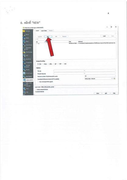
The portal is designed with user accessibility in mind. Interested parties can navigate to One Map Portal and follow the intuitive steps to access a wealth of environmental GIS data. Users can extract map-based information pivotal for managing projects and formulating strategies.
Conclusion
The integration of GIS into the management of natural resources and the environment through the One Map Portal marks a significant advancement in Thailand’s approach to environmental stewardship. By democratizing data access, it lays the groundwork for informed decision-making and sustainable development.
Frequently Asked Questions
“`markdown
What is GIS and how is it used in environmental management?
Geographical Information Systems (GIS) are a critical component in the modern tapestry of environmental management. They serve as a canvas upon which the complex patterns of our natural world are painted, allowing us to visualize, analyze, and interpret geographical data. By understanding the relationships and trends within this data, stakeholders are equipped to make decisions that are rooted in a deep awareness of the environment’s intricate rhythms and flows.
How does the One Map Portal enhance the accessibility of environmental data in Thailand?
The One Map Portal, an innovative leap birthed by the Office of Natural Resources and Environmental Policy and Planning, acts as a beacon, illuminating the path to consolidated environmental data. It’s more than just a platform; it’s a bridge linking the diverse islands of information strewn across Thailand’s natural resources. With user-friendly accessibility at its core, this portal ensures that anyone from government officials to curious citizens can dive into the nation’s environmental narrative with ease, fostering a collective stride towards sustainability.
In what ways can various stakeholders utilize the information provided by the One Map Portal?
The One Map Portal does not discriminate in its embrace; it is a wellspring of empowerment for all who approach it. Government agencies can wield this data as a shield and sword, defending against the onslaught of ecological challenges and cutting through the thicket of developmental hurdles. Researchers find in it a lighthouse, guiding them through the fog of scientific inquiry. The public, with map in hand, can navigate the societal landscape with an enlightened perspective, participating in urban planning dialogues or advocating for conservation. It’s a versatile tool, shaping the future of Thailand with each strategic application, from tracking ecosystem health to sculpting policies with precision.
“`