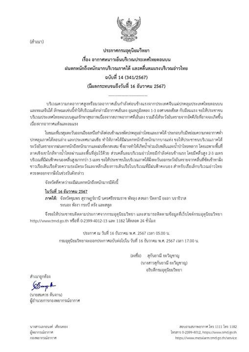
Weather Conditions and Affected Provinces
Upper regions of Thailand are expected to experience scattered thunderstorms, gusty winds, hail, and possible lightning strikes from May 8-10, according to the Meteorological Department. This weather is being influenced by a moderate high-pressure system originating from China, extending over the upper Northeast Region of Thailand and the South China Sea starting from Monday. Concurrently, southerly and southeasterly winds are bringing humidity from the Gulf of Thailand and the South China Sea to the upper part of the country, where hot to very hot weather persists.
Safety Precautions
During severe weather, people are advised to avoid big trees, unsecured structures, and billboards. It’s also recommended not to wear or carry metal while outdoors.
Provinces Affected
May 8:
- North: Mae Hong Son, Chiang Mai, Chiang Rai, Lamphun, Lampang, Phayao, Nan, Phrae, Uttaradit, Sukhothai, Tak, Kamphaeng Phet, Phitsanulok, Phichit, and Phetchabun.
- Northeast: Loei, Nong Khai, Bung Kan, Nong Bua Lamphu, Udon Thani, Sakon Nakhon, Nakhon Phanom, Chaiyaphum, Khon Kaen, Kalasin, Mukdahan, Maha Sarakham, Roi Et, Yasothon, Amnat Charoen, Nakhon Ratchasima, Buri Ram, Surin, Si Sa Ket, and Ubon Ratchathani.
- Central: Nakhon Sawan, Uthai Thani, Chai Nat, Kanchanaburi, Ratchaburi, Suphan Buri, Lop Buri, Saraburi, Sing Buri, Ang Thong, Ayutthaya, Samut Songkhram, Samut Sakhon, Nakhon Pathom, and Bangkok and its vicinity.
- East: Nakhon Nayok, Prachinburi, Sa Kaeo, Chachoengsao, Chon Buri, Rayong, Chanthaburi, and Trat.
May 9:
- North: Mae Hong Son, Chiang Mai, Chiang Rai, Lamphun, Lampang, Phayao, Nan, Phrae, Uttaradit, Sukhothai, Tak, Kamphaeng Phet, Phitsanulok, Phichit, and Phetchabun.
- Northeast: Loei, Nong Bua Lamphu, Udon Thani, Chaiyaphum, Khon Kaen, Kalasin, Maha Sarakham, Roi Et, Nakhon Ratchasima, Buri Ram, and Surin.
- Central: Nakhon Sawan, Uthai Thani, Chai Nat, Kanchanaburi, Ratchaburi, Suphan Buri, Lop Buri, Saraburi, Sing Buri, Ang Thong, Ayutthaya, Samut Songkhram, Samut Sakhon, Nakhon Pathom, and Bangkok and its vicinity.
- East: Nakhon Nayok, Prachinburi, Sa Kaeo, Chachoengsao, Chon Buri, Rayong, Chanthaburi, and Trat.
May 10:
- North: Mae Hong Son, Chiang Mai, Chiang Rai, Lamphun, Lampang, Tak, and Kamphaeng Phet.
- Northeast: Roi Et, Yasothon, Amnat Charoen, Nakhon Ratchasima, Buri Ram, Surin, Sisaket, and Ubon Ratchathani.
- Central: Uthai Thani, Suphan Buri, Kanchanaburi, Ratchaburi, Ayutthaya, Samut Songkhram, Samut Sakhon, Nakhon Pathom, and Bangkok and its vicinity.
- East: Nakhon Nayok, Prachinburi, Sa Kaeo, Chachoengsao, Chon Buri, Rayong, Chanthaburi, and Trat.
Impact on Andaman Sea
From May 8-14, a low-pressure cell over the lower Bay of Bengal is expected to develop into a tropical storm, moving from the middle of Bengal Bay and upper Andaman Sea to the coastal area of Myanmar. Consequently, stronger southwesterly winds will affect the Andaman Sea and Thailand, resulting in heavy to very heavy rain in some areas.
Marine Warnings
Waves in the upper Andaman Sea will reach 2-4 meters high and 4 meters high in areas with thundershowers. In the lower Andaman Sea, waves will be about 2 meters high and over 2 meters in areas with thundershowers. All vessels are advised to proceed with caution, and small boats operating in the upper Andaman Sea should remain ashore.